
Catastrophic Potential: Hurricane Beryl reaches category 5 and heads towards Jamaica

The hurricane, which has already caused damage to the Caribbean island of Carriacou with winds of 240 km/h, is strengthening rapidly and could reach winds of up to 260 km/h. There are forecasts that the hurricane will hit Jamaica on Wednesday (3), continuing its trajectory towards Mexico.
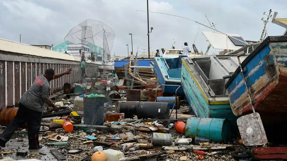
Fishing boats in Barbados suffered significant damage - Photo Reproduction/Getty Images
The Caribbean region is on high alert as Hurricane Beryl approaches, gained strength and was reclassified recently as Category 5 on the Saffir-Simpson scale, the highest and most devastating level for hurricanes. The phenomenon, which has already been classified as "highly dangerous", has the capacity to reach speeds of up to 260 km/h. The storm is currently moving at an alarming speed towards Jamaica, with a direct impact on the island expected tomorrow.
The United States National Hurricane Center (NHC) announced on Monday night (1st) that the hurricane is approximately 1,500 km away from Jamaica, posing an imminent risk of catastrophic damage. According to NHC estimates, The hurricane is expected to pass through Jamaica on Wednesday (03). Forecasts also point to the occurrence of intense rain, with the possibility of flooding in certain regions of the country.
Over the next few days, the hurricane will continue to advance across the Caribbean toward the coast of Mexico. However, according to authorities' projections, the phenomenon is expected to lose intensity over time. Even so, alerts were issued for the Cayman Islands, Belize and cities located in the southwest of the Gulf of Mexico.
Hurricane Beryl
Hurricane Beryl seen from space - Video Reproduction/Reuters
Beryl formed in the Atlantic a few days ago and quickly gained strength due to favorable atmospheric conditions, such as exceptionally warm ocean waters and little interference from wind shear. The storm, which on June 25th was just an atmospheric instability, prone to the formation of storms, turned into a tropical storm on the 28th of the same month, with forecast winds of 56 km/h. Later, on June 30, it developed into a Category 1 hurricane and in less than 24 hours passed category 4, indicating an extreme danger alert, with gusts of wind reaching speeds of up to 240 km/h. It then rapidly escalated to Category 5.
With sustained winds of 260 km/h and gusts that can exceed 300 km/h, Beryl poses a serious danger to any area in its path. The hurricane's central barometric pressure dropped to 920 hPa, indicative of its immense strength and destructive potential. According to the NHC, it is extremely rare to have such a powerful storm at the beginning of the hurricane season, which occurs from June to the end of November in the Atlantic.
According to experts, the rapid growth of Beryl is attributed to the boiling waters present in the ocean. Temperatures in the storm's formation area are registering up to 3°C above average. At the end of May, the United States National Oceanic and Atmospheric Administration (NOAA) had already predicted that this year's hurricane season would be "exceptional", with the possibility of up to seven category 3 or more intense storms occurring.
Devastation in the Caribbean
Hurricane Beryl tore doors, windows and roofs off homes in the southeastern Caribbean on Monday after slamming into Grenada's Carriacou island as the first Category 4 storm in the Atlantic, driven by record warm waters. Grenada Prime Minister Dickon Mitchell reported on Monday night that one person had died and that authorities have not yet been able to assess the situation on the islands of Carriacou and Petite Martinique. There were initially reports of extensive damage, but communications were practically inoperative.
"Within half an hour, Carriacou was devastated," Mitchell said at a press conference, as reported by Agence France-Presse.
Later, in social media posts, the prime minister mentioned that the government was organizing aid to be sent to Carriacou and the island of Petite Martinique on Tuesday. He wrote on Facebook: "The state of emergency continues. Please stay at home." From the island of St. Lucia south to Grenada, streets were littered with shoes, fallen trees, power lines and other debris. Banana trees split in half dotted the scene, while dead cows lay in the green pastures, next to makeshift houses made of tin and plywood leaning precariously.
Preparations in Jamaica and Haiti
Faced with the imminent threat, Jamaican authorities are already taking precautionary measures to minimize the impacts of the storm. The Jamaican government has issued a hurricane warning, recommending that residents in low-lying, flood-prone areas seek shelter immediately. In Kingston, a waiter told the Reuters news agency that the mood was calm in the capital, adding: "Jamaicans usually wait until the last moment. Panic sets in the night before or in the morning. We are used to it."
Meanwhile, the mayor of Montego Bay, a resort town, warned residents not to adopt a "wait and see" approach, emphasizing the importance of being prepared for any eventuality. Before hitting Jamaica, Hurricane Beryl could also cause damage in Haiti and the Dominican Republic, countries that share the island of Hispaniola. Haiti, which has faced devastating earthquakes in the past and whose interim government is fighting to regain control of the capital from the hands of powerful gangs, is particularly vulnerable to the possible damage that Beryl could cause.


